May newsletter
Councillor Adam Boyden
Somerset Councillor for Frome North (Lib Dem) Learn more
May newsletter
April news
Somerset Council agrees budget
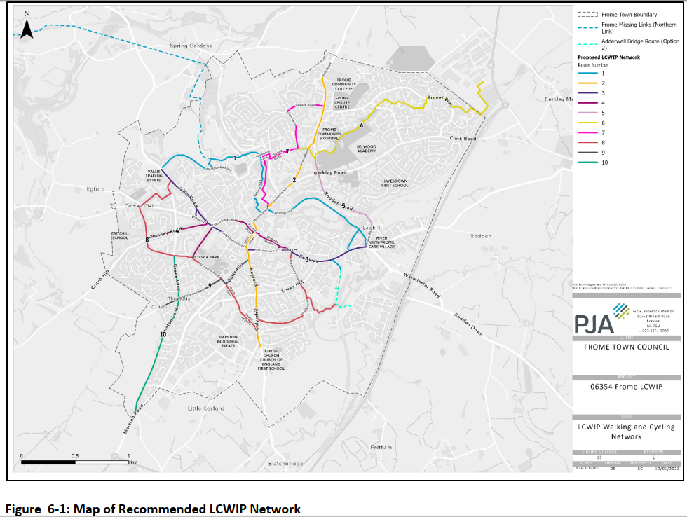
Frome Local Cycling and Walking Plan
by adamboyden on 16 April, 2023
A new Local Cycling and Walking Infrastructure Plan for Frome, which the Town Council adopted at its meeting on 19th April, could lead to improvements in walking and cycling routes, more pedestrian crossings, lower speed limits and more ‘low traffic neighbourhoods’. The complete plan can be seen here.
The LCWIP has been led by Frome Town Council in partnership with Somerset (County) Council, and aims to support the creation of more safe routes for walking, cycling and wheeling to and from key destinations across town. I attended one of the workshops and a councillor briefing earlier this year. The report notes ‘Journeys within Frome are less than 2.5 miles, making it an ideal size for walking, cycling and wheeling. However, the reality is that lack of appropriate infrastructure such as dropped kerbs and safe
crossings make some routes impossible to navigate in a wheelchair or while pushing a pram….’
The LCWIP recommendations identify preferred routes and areas as priorities for investment, including improved pedestrian crossing points, footways and cycle routes throughout Frome and the extension of the 20mph speed limit from the town centre (including through Fromefield to Bath Road, in Stonebridge and Welshmill, and along Rodden Road).
All of the recommendations in the LCWIP will require detailed design and consultation before being implemented, as funding is made available. Adoption of the LCWIP by Frome Town Council and then Somerset Council (as part of an emerging Local Transport Plan) will enable bids to be made for Department for Transport active travel funding, S106 funding and local council budgets. The report by FTC can be found here and the LCWIP report is here. The complete plan can be seen here.
Recommendations for parts of the Frome North area are copied below (see the LCWIP pages 61 onwards for all areas). A design recommendation spreadsheet in Appendix B splits the design interventions into three categories:
- Design Priority (0-3 years) – measures which should be prioritised over other measures to
ensure a satisfactory level of service along LCWIP routes. Typically, these measures should be
delivered in the short-term. - General Design Recommendations (3-8 years) – The majority of design measures fall into this
category and would be considered less of a priority than measures in “Design Priority”. - Design Maximum (8+ years) – generally more ambitious measures that might require a longer
time period for implementation or may require a greater ground swell of public support. For
instance, Low Traffic Neighbourhoods (LTNs), town-wide 20mph or removal/reduction of traffic through the town centre.
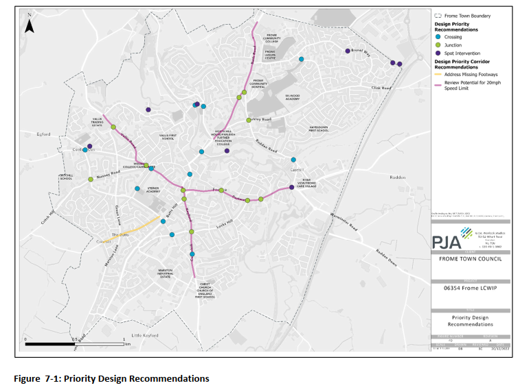
Design Priorities include:
Route 2: Frome Community College to Mount Pleasant via Bath Road and Keyford:
- Review layout and crossing points at critical junctions along the route, such as Gorehedge, Bath Road/Rodden Road and B3092/Rossiter’s Hill/Locks Hill. Consider if a redesign of the junction is required to bring walking and cycling provision to a sufficient standard.
- Provide protected facilities for cyclists and upgrade pedestrian facilities at Bath Road / Princess Anne Drive to improve access for pedestrians and cyclists to Frome College.
- Consideration of corridor‐wide 20mph limit
- Address B3090 corridor (Bath Road, North Parade) and B3029 Keyford corridors to improve conditions for walking and cycling. Improvements should focus on improved crossing facilities, side-road treatments, tighten geometry at side-road junctions, consideration of 20mph speed limit, centre-line removal and footway widening where possible.
Route 5: Warminster Road to Frome Community Hospital via Rodden Road:
- Provide pedestrian crossing at Rodden Road ‐ Railway Bridge to get pedestrians from south‐western to north‐eastern footway.
- Increase green man times at Berkley Road junction and provide dedicated facilities for cyclists
- Resurface footways and review side road treatments along route and ensure dropped kerbs + tactile paving at a minimum.
- Extend Rodden Road shared use path from Community Hospital to Berkley Road junction and upgrade to LTN compliant facility where peds/cyclists are separated if carriageway width allows. This could link up with Route 2 to provide protected facilities for the length of Bath Road/Rodden Road to improve access to key trip generators
- Reduce vehicle speeds along Rodden Road (south of Berkley Road) by implementing 20mph speed limit and traffic calming through centre‐line removal, formalising on-street parking with associated public realm improvements + footway widening where possible (N.B. this is absent from the map in Figure 7-1 above).
Route 6: Spring Road to Commerce Park via Showfield and Brunel Way:
- Upgrade unsurfaced section of footpath to Commerce Park to shared-use route at least
3m in width (if possible) – delivered through proposed commercial development. - Provision of raised table crossing point with tactile paving on Forest Road to facilitate
walking/cycling route between Showfield and Brunel Way. - Improve transition between Brunel Way and shared use route to Forest Road by introducing dropped kerb + associated signage/road markings.
- Improve existing crossing of Fromefield/Spring Road/Rodden Road junction to incorporate controlled pedestrian and cycle crossing of Fromefield.
- Widening of shared-use route through Showfield and onwards to Brunel Way to achieve minimum width of 3m (where possible). Provision of surface markings to denote shared-use route, enforce pedestrian priority and encourage slower cycling speeds.
- Investigate lighting solutions for route through Showfield and north of Stonebridge Drive.
- Investigate potential for segregated cycle facilities on Brunel Way, or alternatively traffic calming/speed reduction measures (20mph) to bring in line with LTN 1/20.
- Provide wayfinding along route to direct pedestrians & cyclists to town centre and also Commerce Park.
- Look at LTN approach for Stonebridge Estate.
Route 7: Market Place to Bath Road via Spring Road and Grange Road:
- Provide controlled crossing point to facilitate route between Spring Road and River Path
across Welshmill Road. - Improve transition from Welshmill Lane onto River Path by increasing width of path,
widening dropped kerb and raising crossing point to footway level with existing guard
railing removed. - Review side road treatments along route and ensure consistency and/or provision of
dropped kerbs + tactile paving at a minimum. - Review footway provision along Leys Lane/Grange Road to ensure surface is smooth and
footways are continuous (i.e. no gaps in provision), or informal crossing points are
provided where footway provision ends. - Investigate potential for lighting solution along River Path to ensure route is usable year-
round. - Extend 20mph speed limit to cover Welshmill Road/Welshmill Lane. Introduce 20mph
limit within Spring Road/Leys Lane/Grange Road residential area. - Wayfinding to signify quiet alternative route between Bath Road and town centre/River
Path. - Look at LTN approach for area surrounding Welshmill Road and Bath Road.
Applying a Low Traffic Neighbourhood approach to residential areas will need much further thought, as many of these areas already have cul-de-sacs which considerably limit through traffic in most side streets.
To have your say, make a comment, support or raise issues please contact the Town Council or get back to me.
1 Comment
We also need a 20mph speed limit on Innox Hill. Lots of pedestrians (including those with small children in buggies) and cyclists walk here and there’s no pavement, yet cars and vans travel faster than 30mph.